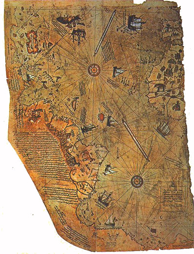
A 500-year-old map that shows Antarctica before it was discovered.
Antarctica is treated like a solved problem. A continent at the edge of the world, buried under ice, mapped, studied, and accounted for. Whatever questions once existed about it were answered long ago, or at least that is how it gets presented. What tends to get less attention is how little of it has actually been seen in any direct sense. Most of what we know about the land beneath the ice comes from indirect methods: seismic readings, satellite data, reconstruction. It is a place that is both heavily studied and largely inaccessible, and that combination leaves more room for uncertainty than the official version of it tends to acknowledge.
That uncertainty becomes harder to ignore when something surfaces that doesn’t fit cleanly into the timeline.
In 1513, an Ottoman admiral named Piri Reis produced a map. A surviving fragment still exists. It shows parts of Europe, Africa, and South America with an accuracy that is striking for the period, detailed enough that some researchers have suggested it resembles a view from above rather than something assembled from ship logs and coastal surveys. What continues to draw attention is what appears along its lower edge. There is a coastline there that, depending on how it is read, bears a resemblance to Antarctica, not as it looks today, but as it would look without its ice.
Some of the modern overlays are hard to ignore. When the map is rotated and placed against what lies beneath the Antarctic ice sheet, parts of the coastline align in a way that feels closer than coincidence should allow. That could be the flexibility of the comparison. It could be pattern recognition doing what it always does. But once the resemblance is seen clearly, it does not disappear easily, and that alone is worth taking seriously.
The standard objection is straightforward. Antarctica was not officially sighted until 1820, when a Russian expedition first recorded the Antarctic mainland. The land beneath its ice was not mapped with any real precision until the twentieth century. Most historians and cartographic scholars read the southern landmass on the Piri Reis map as a distorted extension of South America, or as Terra Australis, the speculative continent that appeared on many early maps as filler for unknown southern latitudes. That explanation is reasonable. It is also convenient in a way that makes it worth examining more carefully.
Piri Reis himself did not claim the map was his own work. In his notes, he stated that he compiled it from earlier sources, some of which he described as already ancient at the time. That detail matters more than it usually gets credit for. The question shifts from how a sixteenth-century admiral produced such a map to where the underlying information came from, and how old it actually was. Knowledge does accumulate over time. Geographic information can be preserved, copied, and transmitted across generations in ways that are difficult to trace. That is a grounded explanation, and it accounts for part of what is seen.
It does not, however, resolve the coastline. Geological evidence confirms that Antarctica has not always been ice-covered, but those periods extend far beyond the accepted span of human history. For an accurate, ice-free rendering of the continent to exist on a sixteenth-century map, one of two things would have to be true: either the comparison is being misread, or the information came from somewhere that current history does not account for. Most researchers choose the first explanation. That choice is defensible. It is also a choice, not a conclusion the evidence demands.
What makes this harder to set aside is that it doesn’t sit alone. There have been repeated reports of low-frequency signals detected beneath the Antarctic ice during seismic monitoring. Most have explanations: shifting ice, pressure changes, subglacial water moving beneath miles of frozen surface. Antarctica is not as still as it appears. But not every signal resolves cleanly, and in a place that is still mostly buried and largely out of reach, the confident claim that everything beneath it is understood starts to feel less like a conclusion and more like a preference.
That is where the Piri Reis map continues to hold its place. Not as proof of a lost civilization or a collapsed timeline, but as a problem that does not fully resolve under close examination. It sits between explanations, plausible enough under conventional reasoning to be dismissed, but not so completely explained that the questions disappear. The resemblance to the subglacial coastline is real enough that researchers have noted it seriously. The sourcing Piri Reis describes points backward toward something older. And the continent itself remains one of the least directly known places on the planet, still producing data that does not always settle neatly into existing categories.
None of that proves the map is accurate. But it does raise the possibility that the information it contains is older than the map itself, and that whatever it was copied from reflected a geography that should not have been accessible to anyone at that time. That is not a comfortable possibility. It is also not an impossible one.
The map does not rewrite history on its own. What it does is refuse to go away, and after five centuries, that stubbornness is its own kind of argument.
Leave a Reply